Situation of the areas
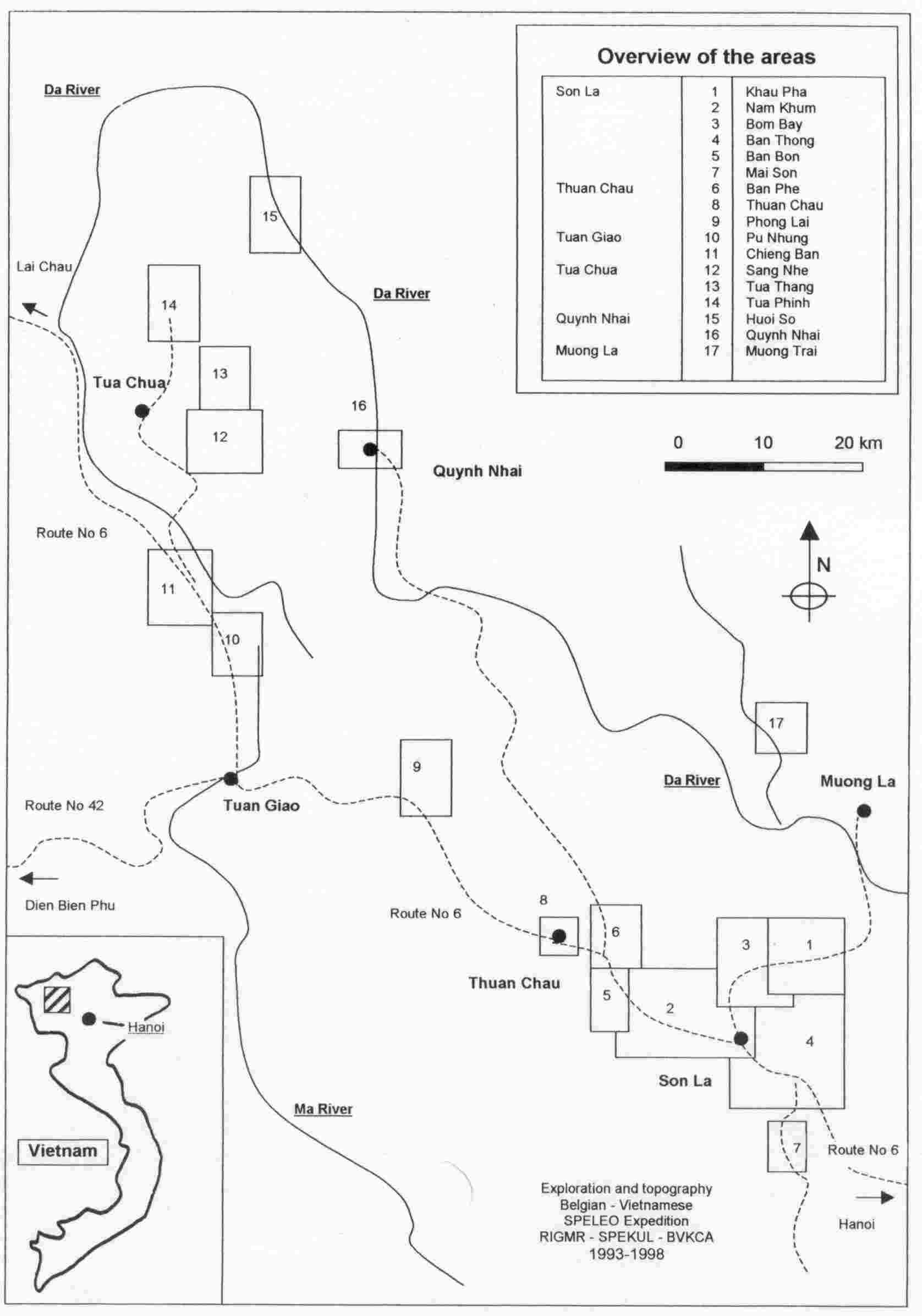
During six caving expeditions, 29 areas were mapped out in Northern Vietnam.
The table below gives an overview of all the areas
that were defined and explored during the caving expeditions, together
with their number and code for further referencing. Updated up to the
2001 expedition.
| Area 1 KP - Khau Pha |
This area was traced out in 1993 around the underground Nam La river area. The area was studied very extensively in 1993, so further exploration was done on the other expeditions. |
| Area 2 NK - Nam Khum |
This area covers some 90 km² to the north-west of Son La. It was traced out in 1993 and expanded in 1995. During the 1997 expedition no further exploration was done here. |
| Area 3 BY - Bom Bay |
This area was defined in 1993 as the transition between area 1 and 4. Three caves were explored during the 2000 expedition. |
| Area 4 BT - Ban Thong |
This area lies to the east of Son La. Exploration was done in 1993 and 1995. |
| Area 5 BB - Ban Bon |
This area was traced out in 1995 to the west of area 2, where the road turns to the north, in order to explore the valleys around the road. No further exploration on the 1997 expedition. |
| Area 6 BP - Ban Phe |
Further to the north, area 6 was defined in 1995 as the area around the underground Nam Muoi river. Two more caves were explored in 2000. |
| Area 7 MS - Mai Son |
Leaving Son La to the south-east, area 7 was marked out along the road to Mai Son, in the karstic area to the north of the Nam Mua river. No further exploration on the 1997 expe. |
| Area 8 TC - Thuan Chau |
This new area was traced out during the 1997 expedition as the area around the village of Thuan Chau. Just one cave was found in this area. |
| Area 9 PL - Phong Lai |
This area was traced out during the 1995 expedition as the Lai Vai area, but was renamed in 1997 to the Phong Lai area. Three new caves were found in 1997. |
| Area 10 PN - Pu Nhung |
This area was traced out in 1997 between Tuan Giao and Tua Chua, to explore the valleys of Ban De Chia. |
| Area 11 CB - Chieng Ban |
This area was traced out in 1997 between Tuan Giao and Tua Chua, to the north of area 10, and covers the underground system of the Chieng Ban river. |
| Area 12 SN - Sang Nhe |
This very interesting area was explored in 1997. It covers the region to the southeast of Tua Chua, where a lot of rivers disappear underground. Ban De 2 cave was revisited in 2000 to take pictures and to explore one new gallery. |
| Area 13 TT - Tua Thang |
This area was traced out in 1997 as the region to the north of area 12, where the same phenomena as in area 12 can be observed: important rivers disappearing underground. Area 13 is more remote, and could not be prospected as extensively as area 12. More work has to be done here. |
| Area 14 TP - Tua Phinh |
Following the road further to the north, some interesting caves were discovered and grouped in the area 14 in 1997. From here the road stops. Further exploration should be done by horse and on foot. More work has been done in Ta Chinh in 2000, but further investigations were halted by bad weather conditions (flooding). |
| Area 15 HS - Huoi So |
We travelled from the city of Quynh Nhai along the Da river by boat and explored the banks of the river. The most remote area we reached in 1997 was named area 15. During next expeditions, the Da river will be followed further to the north. |
| Area 16 QN - Quynh Nhai |
This area covers the area in front of the city of Quynh Nhai. Only one cave was explored here in 1997, but climbing up that valley might be very interesting during next expeditions. Along the banks of the Da river, no points of interest were found in between area 15 and 16. |
| Area 17 MT - Muong Trai |
The Muong Trai area was traced out in 1997 because of its important location near Muong La, where plans are lined out to build a dam on the Da river. Caves cause serious problems when retaining water in a Karst area. All caves, including small ones, are important to report in this area. |
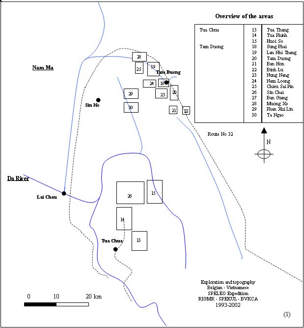
| Area 18 SP - Sung Phai |
This new area was traced out around Tam Duong town. Two caves have been explored in 2000. |
| Area 19 NT - Lan Nhi Thang |
This area is situated along the main road number 32 that connects Tam Duong city to the north-west of the country. Two very deep caves have been explored here. |
| Area 20 TD - Tam Duong |
This area is also situated along the main road number 32, but at the south east-side of Tam Duong City, where four caves were discoverd in 2000. |
| Area 21 BH - Ban Hon |
Ban Hon area is situated to the south of area 20, further away from the main road. Five caves were discovered in 2000, all belonging to the same hyrological system of the underground river near Dong Pao. |
| Area 22 BL - Bin Lu |
This area was traced out in 2000 to cover the site where the showcave of Tien Son is located. No further caves were found in this area, because the end of the karst region was reached |
| Area 23 NN - Nung Nang |
This area was traced out in 2001 to the South West of Tam Duong Town (area 18). In this area several caves were found that give onto the same underground river. Although the entrance porches are impressive, development is always minimal. 5 new caves were surveyed. |
| Area 24 NL - Nam Loong |
New area traced out in 2001 to the west of Tam Duong Town
(area 18). 3 new caves were found in 2001. The underground river of the
Nung
Nang area resurges to the west of the new road towards Sin Ho and
disappears again in the huge porch of Hang Nam Loong. In 2002, 3 more
caves were found, incliuding Xa Nam Loong 4, 1203m long. |
| Area 25 CS - Chieu Sai Pin |
Newly defined in 2001 to the west of area 19. Although only two caves were found and explored so far in this promising area, the second one (Cong Nuoc) immediately became the deepest cave of Vietnam with an estimated -410m and going. It reached -600m in 2002 |
| Area 26 SC - Sin Chai |
The road from Tua Chua to the north continues further north past Ta Xin Thang village and ends in Sin Chai. The road will eventually cross the Da river and link with Sin Ho. 4 caves were explored in Cang Ti village with very deep entrance pitches in 2001. Exploration continued in 2002 and two more sinkholes were found next to Sin Chai village. |
| Area 27 BG - Ban Giang |
Area to the south east of Tam Duong Town, defined in 2001 |
| Area 28 MX - Muong Xo |
This area was defined and explored in order to look for caves to the north of Chieu Sai Pin area, close to the crossing of Route 4 and 100. Few phenomena were found (Pa So Resurgence), no caves were mapped |
| Area 29 PX - Phan Xui Lin |
This area, to the southwest of Tam Duong and in Sin Ho district was defined around the end of route 605 in Pan Xui Lin village. 16 karst phenomena were checked, often choked (Hospital Cave or Bien Fang (-37, 276m), Ta Phin 7 (-40, 136m)) |
| Area 30 TG - Ta Ngao |
This area, to the south of area 29 was the second one explored in Sin Ho region. 12 karst phenomena were found (Cang Dung, 18, 305m, Kho Pua 1, -63, 170) |
| Area
31 Tan Lac |
This area is located nearby Cuc
Phuong national park in Hoa Binh province at about 130 km to the west of Hanoi. All caves are defined in one area. On topographical map Mai Chau (F48-127-A) |
| Area 32 Ba Be |
The area is in the national park Ba Be (3 lakes) in Bac Kan province, 68 km from Bac Kan town, 254 km from Hanoi. All surveyed caves are defined in one single area. On topographical map Cho Ra (F-48-44-A) |
| Area 33 Dong Van |
This area comprises the city Dong Van and the area to the west of the city. On topographical map Dong Van (F48-31-B) |
| Area 34 Pho Bang |
The area is located to the west
of Dong Van area. On the topographical map Doan Ket (F48-31-A). |
| Area 35 Meo Vac N |
The area belongs to the Meo Vac District (to the north of Meo Vac city), but is situated on the topographical map ‘Dong Van’ (F48-31-B) |
| Area 36
Meo Vac E |
The eastern area on the
topographical map ‘Meo Vac’ (So Hieu 6655 II) |
| Area 37 Meo Vac W |
The western area on the
topographical map ‘MeoVac’ (So Hieu 6655 II) |
| Area 38 Yen Minh N |
Southern most area on
topographical map ‘MeoVac’ (So Hieu 6655 II), belonging to the Yen Minh
district. |
| Area xx MC - Moc Chau |
On the way back to Ha Noi in 1997, a stop was made in Moc Chau. This area wasn’t numbered yet because no maps were available to pinpoint the cave entrances. |
| Area xy NP - Nam Phe |
This area did not get a number due to the unavailability of the map. It is located to the north of area 19 and area 25 |
Situation of the areas