AREA 14: Tua Phinh
TP1 Ta Chinh
1997-1998
The dirt road towards the north from Tua Chua gets worse, and even
unsafe, as it’s also muddy and there’s a deep rift below.
The entrance porch, in which a small river disappears, lies close to
the road in the village of Ta Chinh and is flanked by two high bamboo
trees.
The grey walls in the entrance area are well polished, hampering the
climb
down. After about 30m, a 15m pitch was abseiled, leaving the local
Hmong
kids behind. It was new years' eve 1997.
 Below
the pitch there's a small basin, followed by a spacious gallery. At the
end, the narrowing passage is choked with soil, bamboo and debris
supplied
by the river during the rainy season. Below this choke a crawl through
a narrow and muddy tube gives into a little chamber which looked like
the
end of the cave. The way on lies behind a boulder which looks like the
wall of the chamber. Climbing up and down boulders then leads to a
slope,
where the cave widens and a small river is found. In this water, a
white
freshwater crab was found, as well as tadpole-like creatures. A 4m step
gives into a room, where a P7 above a basin leads into a canyon. The
way
on is a series of steps and small basins. Two consecutive P8s give way
to a larger room, where the way on lies underneath a polished natural
bridge
(P7). A natural ridge brings you to a widening porch of a wide chamber
filled with huge blocks. A perfectly flat slope brings you down to a
more
horizontal gallery. Here the way on is obstructed by boulders and
flowstone.
Below
the pitch there's a small basin, followed by a spacious gallery. At the
end, the narrowing passage is choked with soil, bamboo and debris
supplied
by the river during the rainy season. Below this choke a crawl through
a narrow and muddy tube gives into a little chamber which looked like
the
end of the cave. The way on lies behind a boulder which looks like the
wall of the chamber. Climbing up and down boulders then leads to a
slope,
where the cave widens and a small river is found. In this water, a
white
freshwater crab was found, as well as tadpole-like creatures. A 4m step
gives into a room, where a P7 above a basin leads into a canyon. The
way
on is a series of steps and small basins. Two consecutive P8s give way
to a larger room, where the way on lies underneath a polished natural
bridge
(P7). A natural ridge brings you to a widening porch of a wide chamber
filled with huge blocks. A perfectly flat slope brings you down to a
more
horizontal gallery. Here the way on is obstructed by boulders and
flowstone.
Behind these obstacles lies a beautiful master cave, now dried out.
The bottom is covered with pebbles, progression is easy and big fun.
Here
and there the roof comes down, necessitating small crawls. On the
northern
side, boulder slopes (possibly inlets, not checked) join the cave. We
stopped
exploration in a wide chamber, filled with blocks, but the cave goes
on.
Our best New year's present so far!
| Pitch |
Rope |
|
| P15 |
25m |
1 Natural Thread + Tape
1 Gloch
1 Bolt |
| R8 Slope |
15m |
1 Natural Thread
1 Bolt |
| R6 |
20m |
1 Natural Thread + Long Tape
1 Bolt |
| R5 |
10m |
1 Natural Thread + Tape
1 Bolt |
R3
R4
P8
P8 |
24m |
No ropes
1 Natural Thread , 1 Bolt
1 extra bolt could be useful
1 Natural Thread, 1 Bolt |
| P7 Stone Bridge |
10m |
1 Natural Thread, Tape |
| P14 Slope |
16m |
1 Natural Thread, 1 Bolt |
Click here to view a
topo of Ta Chinh (59 kB)
February 2000:
Day One:
Christophe and Vince start rigging the cave whilst Peter, Lieven and
Steve explore drafting holes further north of Tua Phinh. The muddy
'rabbit
hole', a 50cm high flat crawl on top of debris close to the entrance
area,
turned out to be completely washed away (compared to 1997-98). The
appearance
of the boulder choke behind it also changed. The known galleries were
rigged
and Terminus 98 was reached. A wide gallery followed a climb down huge
blocks. The passage gets wider and is obstructed at some points with
massive
blocks. A mud slope across the passage brings us down to the western
side,
at the bottom of some large white flowstone, where a series of pitches
starts going down. We went back because lack of rope. On the way back
we
got lost in the wide gallery; side passages joining the main gallery
and
the large blocks confused us. We decided to go back to the flowstone,
and
eventually found our way out. We decided to mark the track with
reflectors
during the next trip (El Sendero Luminoso).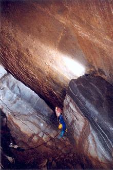
Day Two:
Vince and Xtof survey the new passage, whilst Steve, Lieven and Peter
rig and descent the pitches. On the bottom, the passage becomes wide
again,
after a squeeze between flowstone. Another series of deep pitches
(estimated
at 50m) is reached at a depth of -290m. Again we go back due to lack of
rope. Because of continuous rain, no work is done in Ta Chinh for 4
days.
Eventually we decided to go for a last trip, in order to try to get as
deep as possible and retrieve gear that was left behind. In the
entrance
porch, it rained from every crack in the ceiling and a small stream
disappeared
down the P15, nothing too bad, we could go for it! When we arrived at
the
'rabbit crawl' we changed our mind; the passage was filled half way to
the ceiling and collected water from both sides. Christophe estimated
the
sump would close itself after another 4 hours. Whilst Steve
'volunteered'
to be the guardian (angel?) at the sump, Vince, Xtof and Peter decided
to rush down the series of steps and down the two P8s in order to get
the
ropes out. Vince, who was in front, decided also to unrig the P7 and
the
slope towards the master cave, since he left behind his descender out
there.
The item was found after a while (even the passage down the slope
started
to get flooded). The climb up the P7 underneath the natural bridge
('horse
back') wasn't easy, since all of the water is collected here and formed
a cascade. It became clear how that bridge was formed.
We made it back to the sump in 80 minutes, where the water level rose
faster than expected. Steve, who had noticed that it wouldn't take 4
hours
as we estimated when we went in, designed an evacuation plan. He just
finished
scetching on survey paper when we arrived. Inside the cave, the remote
pitches were left behind rigged. Some survey equipment was left on the
flowstone as well. We hope to find it back there during our next
expedition.
December
2000:
Ta
Chinh
cave reaches -402m
After having abandoned
exploration during the 2000 expedition (the siphon near the entrance
flooded due to unexpected rainfall) we returned to finish the job. At
the end of December 2000, we're back on the plateau and are welcomed
again in Xin Thang. Dorien starts the exploration of the cave by
falling 4m down the entrance. The ghost of the cave again proved to be
merciful, she was a bit hurt, but nothing too serious. The siphon
passage was dry again and filled with mud half way. We go down to
-300m, where we prepare the anchors for the descent of the next day. On
our way back, we found back our bag, 60m lower than where we left it
earlier this year. Even though it was tightly closed, the bag turned
out to be completely filled with mud and small pebbles, again
testifying the huge discharges that pass here in the rainy season.
The next day, Christophe
and Vince continue the exploration down a P5 and a steep black slope of
25m in which contrasting white fossils can be found (the same type as
we later found in the 65m entrance pitch of Can Ty, further north).
Here and there the water has cut itself through layers of brown
flowstone, showing a beautiful pattern of concentric circles, up to 1m
in diameter. They again arrived in a dark and spacious gallery with
large blocks that goes down. It seemed to go on forever, straight to
the Da River. Then, the cave becomes more horizontal, again a riverbed.
The ceiling suddenly gets very low, followed by a dry, V-shaped siphon
with mud and pebbles on the floor. Suddenly, the end of the cave seemed
near. The gallery is now just 2m wide and horizontal. It gets narrower
and another dry siphon is passed, which is longer and muddier than the
previous one. Then again the passage becomes more spacious and the
walls more clean, as if the cave decided to show it's known morphology
again. A pitch of 7m is descended after which the gallery again becomes
narrow, one needs to crawl 30m on hands and feet and pass yet another
sandy siphon. Then, a climb down cleanly polished walls leads to a
small basin. From here, the first team started to survey back to -300.
The remainder of the exploration was left to the second team (Peter and
Manuela), which was met below the wide gallery.
The first team leaves the
cave and goes back to Xin Thang, where everyone is very curious. They
are happy to tell that the exploration is not finished yet and that
they hope the cave will go deeper than 400m. Using a pocket calculator
(there is no electricity here to power our computers) we calculate the
depth of the deepest point reached. The basin was at -386, a lot deeper
than we had estimated. Impatiently we await the arrival of the second
team who arrived a few hours later.
They had reached the final
sump after a swim in an active river. Ropes were removed and taken up
to -300m. In the sump, they noticed cave fish and strange frogs with
long, white tails. Peter thinks they might have reached down to -400.
Whilst the second team is having their late night dinner, the others
impatiently process their survey data. The cave of Ta Chinh sumps at
-402m, after 2015m of development through magnificent passageway. It
could be the deepest cave of Vietnam at that moment!
The next morning a large
party goes down in order to retrieve all ropes and to make some
pictures. Do Tuyet, geomorphologist and the leader of the Vietnamese
party wanted to see the cave with his own eyes. His 61 years of age did
not stop him from going down to -200! I've rarely seen someone being so
tired as Tuyet when he came out that night but rarely seen someone
radiate so much happiness and satisfaction!
TP2 Chieu Tinh 1
Follow the river, full of large rounded boulders, to the entrance
porch.
The river is dry in winter, but it is clear that during the rainy
season
an enourmous discharge disappears into the cave. Two children of the
man
who took us to the cave were carried away with the flow and were never
found again. Towards the doline, which lies in fromt of the entrance,
one
has to search for the way on though blocks as large as an average
Vietnamese
house. These actual entrance is hidden behind those blocks and it’s
dimensions
can only be estimated from inside. Here, follow the bed to the right
side,
where a series of steps (one rope required) brings you down along a
joint.
A turn to the right (allmost 90°) brings you to a less high passage
following the bedding plane. After 100m, another 90° turn to the
right
gives into another joint, where the ceiling is again high and the
bottom
covered with blocks. Another turn to the left leads to a worn out
passage
where some large tree trunks can be found. From here, several pitches
lead
down to a lower level where the ceiling is again high. The piches can
be
avoided, using a side passage. At the end a P6 (1 spit), opening like a
bell, can be descended, giving into a pool. From here another gallery,
somewhat smaller, starts. After a turn, the aspect of the cave changes;
the following gallery is more horizontal and the bottom is more
sandy.
Small inlets drip from the walls and the ceiling gets really low.
This passage ends at -92m on two basins which are part of a sump.
Click here to view a topo
of Chieu Tinh (58 kB)
TP3 Chieu Tinh 2
Where the main river in the valley meets the carbonate rocks, it
disappears
into a low cave entrance, which is choked with mud after just 1m.
TP2a
Hang Cho 1
From Ta Xin
Thang, follow the main road back to Ta Chinh. Where the
valley gets narrow, just outside the village of Ta Xin Thang take left
to Hang
Cho – Pao Tinh, follow the old path above
the road (road build in 2001). The cave entrance lies on the hill slope
on the
old path, just before you reach the first houses. It is a fossil pit of
about
15 meters deep with no way on.
<>
TP3a
Hang Cho 2
<><>From Ta Xin Thang, follow the main road back
to Ta Chinh. Where the
valley gets narrow, just outside the village of Ta Xin Thang take left
to Hang
Cho – Pao Tinh, follow the old path
above the road (road build in 2001). Continue to the village center and
stop at
the saddle between the two valleys. When looking at Ta Chinh from the
saddle,
you see a doline in front of you, located on a fault heading straight
to Ta
Chinh. There’s a bamboo trees at the bottom of the doline with a first
pitch.
The main passage lies behind a second pitch, located at the northern
side of
the doline. The pitch dips 60° and gives into fault passage heading
towards Ta
Chinh. During the rainy season a small streamlet flows to Ta Chinh. The
end of
the cave is a muddy sump. A small climb here leads to a second sump
with a lot
of CO2 in the air.
TP4
Hang Cho 3
<>
From
Ta Xin Thang, follow the main road back to
Ta Chinh. Where the valley gets narrow, just outside the village of Ta Xin Thang
take left to Hang Cho – Pao Tinh, follow the new road build in 2001
till you
reach the first houses. Continue till the first U-turn in front of the
village.
The fossil pit opens close to a bamboo bush on the right side. The pit
is 12
meters deep and choked at the bottom.
TP5
Hang Cho 4
Development: 85
Denivelation : -50
Intercalation between
thinly
bedded layers of limestone, sandstone and schist.
From the road
you walk through the village, behind it there is a valley to the left.
From
there you can see a doline almost at the bottom of this valley, adorned
with
beautiful big bamboos. You will find the entrance between some blocks.
First
one has to climb down +/- 7 m into a small chamber with a plated
ceiling. At
the bottom left side there is a S-shaped squeeze with a very strong
draft.
After the squeeze you enter a boulder chamber, where you will have to
find your
way down to the top of a 10m pitch, to be rigged with tapes and a 20m
rope.
Further on there are some steps to climb down and some small passages.
The cave
ends on a tube passage with a bedding of water and mud. The
continuation is too
narrow.
Bats inhabit the cave.
TP6
Tua Chua Phung
Development: 30
(est)
Denivelation : -10 (est)
The wide valley south of tua
Chua Phung village, develops along a main fault. The impressive canyon
ends in
the valley where the river disappears into a wide field with several
sinkholes
which are all choked. Further to the south, several dolines and
sinkholes can
be found, all choked. One a bit more to the side and slightly upward is
interesting; its entrance is right onto the fault. It was briefly
explored till
the way on was too narrow. Behind the obstruction there is a pitch with
water
below.
TP7
Lau Cau Phinh 1
Development: 208
Denivelation
: -99
Development: 57
Denivelation
: -46