AREA 33: Dong Van
DV1:
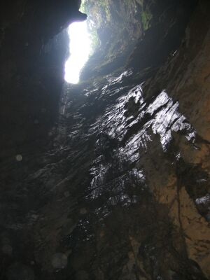
Xa Lung 1
Development: 262 m
Denivelation: -178 m
The entrance of this cave is immediately beneath the road on the left
side just before entering the village Xa Lung. There is another
entrance on the right side. One goes down a steep slope and then into a
doline which gives way to a beautiful and large pitch (P114).
Descending this pitch, one lands
in a rather big chamber (25m in
diameter) with a flat muddy bottom and a sump at the far left side. No
way on could be found, although the dimensions of the site left us
dreaming of a huge collector system.
DV2:
Xa Lung 2
Development: 700m
Denivelation: -340m
Xa Lung 2 is situated at the left hand side of the road entering the
village Xa Lung coming from the direction of Dong Van. The path passes
first the entrance of Xa Lung 1 (left side) a few hundred meter further
(right site) a depression in the fields gives way to a canyon.
Following the canyon a first steep boulder slope is descended (R9). A
short passage gives to a P21, it is a descent in a kind of a joint. At
the bottom a larger room with some huge blocks is found. Day light
enters the cave from above via a P35, which is descended two days later
and called ‘the flying goat’ pitch. The reason of an unpleasant smell
is found after a next step down: in a round room a rotting goat is
found. At the opposite side of the room the top of a deep pitch is
reached. The pitch, with a free hang of 44 m at the end, brings us to
-120 m. At the bottom a lake can be avoided via a pendulum. The cave
continues with small drops, followed by small lakes at the bottom. At
the moment of the exploration no flowing water was present, but the
clean walls suggest a huge discharge during rainy season. After a P20
the cave becomes more narrow and sportive. A nice meander gives to a
P27, the passages are larger again. At the first real inlet a flowstone
almost chokes the passage, but at the bottom the cave continues with a
P23. When the passages (3 to 5 m wide) go up again a small window gives
way to small drops: a P10, P11. Then the cave development changes
completely. A horizontal muddy collector is reached. After about 120 m
the ceiling comes down and a sump is reached, at a total depth of -340
m. The last pitch is almost exactly situated below the entrance. The
plan of the cave shows that the passages turn below each other,
resulting in a screwdriver like development.
DV3:
Ma Le 1 and DV4: Ma Le 2
Development: 218 m (DV3) & 893 m (DV4)
Denivelation: -56 m (DV3) & 44 m (DV4)
Ma Le 1 and 2 constitute together the underground course of relatively
important river. They are connected by a sump. The river disappears in
a large porch at the bottom of a beautiful and deep valley below the
village Ma Le. However the access to the underground course is through
another big porch approximately 100 m to the right of the first one and
some 30 m higher. Here a boulder slope and a short drop of 20 m at the
right side allows one to join the river. The river can be followed for
about 150 m through a nice gallery (7 x 4m) to a sump. According to
local people, the sump can be dived free, but we didn’t give it a try
since all the rubbish was not very inviting. Ma Le 2 is an entrance at
the other side of the mountain and gives access to a continuation of
the river. Upstream the river can be followed over approximately 800
meters before a sump is reached. This sump is supposed to be the one of
Ma Le 1. The gallery leading towards this sump is large and really
beautiful. It starts by two waterfalls of about 4 to 5 m which can be
climbed either to the right or the left side. Then the gallery widens
up and allows an easy walk along many beautifully decorated walls.
Downstream the river can only be followed over a short distance. This
part quickly ends in a sump between pebbles. The water of the Ma Le
river reappears in fact a few hundred meters further in the same
valley, but there is no entrance to be found here.
DV5:
Tia Sang
Development: 1154 m
Denivelation: -107 m
In this area the water is flowing in many small rivers on top of the
siltstone. When the water reaches the limestone it disappears in
different sinkholes over more than one kilometer. Tia Sang cave is the
only sinkhole which can be entered. It is situated at the contact
between the limestone and the siltstone at the bottom of a deep
depression and under a huge limestone wall. This active cave develops
along a fault axis and is mainly directed south. It starts with some
vertical passages. The river which is flowing down in different steps
can be avoided with a horizontal traverse above the water. Descend
approximately 7 m and swing away from the entrance over 3 m. A window
opens at the right side. This window gives way to a dry seriesof small
pits. Three natural anchor points can be used to descend to the foot of
a small waterfall. A spit allows to descend another 12 m, a final spit
allows to descend the last 4 m.
The underground river can be followed over approximately 300 m to a
chamber in T-shape. To the left the cave turns back. The river flows to
the right in a gallery of approximately 6 m high and 20 m wide. The
right side of the gallery is a big mud slope. Soon the river can not be
followed anymore.
This passage can be bypassed at the high right side, where a window
high up the mud slope gives access to the continuation of the river.
Stay high up the mud slope till an important inlet is met at the left
side. At this point, slowly descend to the river. The river can then be
followed over several hundreds of meters, the size of the gallery is at
most times reduced to a few meters high and wide. Suddenly the gallery
gives access to a gallery of big dimensions: 10 m high, 30 m wide.
Several muddy inlets feed the river during rainy season. The river
finally ends in a big sump lake: 20 m by 20 m. This sump is certainly
worth to be dived. The water is supposed to feed the resurgences around
Dong Van city.
DV7:
Xa Xa Phin 2
Development: >200 m
Denivelation: -
During our visit obvious signs of earlier speleological investigations
were found in the cave. We didn’t continue the survey as we expected to
find the same results of the former speleological investigation. Until
now no data about this cave are found.
DV8:
Xa Xa Phin 1
Development: 191 m
Denivelation: -32 m
Old fossil cave, large room.
DV9: Hmong Castle
Development: 74 m
Denivelation: -29 m
The entrance of the cave is right next to the road. It is an old
sinkhole, filled with blocks from road works. One can walk down to the
bottom, where a few concretions are present and water is seeping in.
DV 10: Hang Ho
Development: 337 m
Denivelation: -14 m
One can follow the stream for about 300 m until reaching a sump. At
several places the ceiling becomes very low. Lots of debris can be seen
on the walls and ceiling from periods when the water level is higher.
Close to the end of the cave is an inlet with more than half a meter of
wet mud.