1995-2000
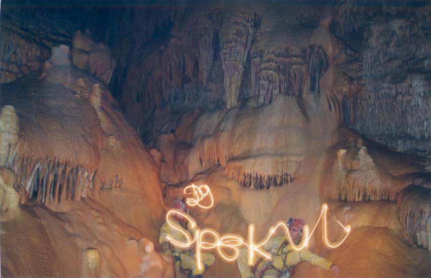
Introduction
 Mar
Challita cave (named after a nearby chapel devoted to Saint Challita),
below the village of Qnat, North Lebanon, has been well known since the
Bronze Age. It was explored in the early fifties by SCL and mapped for
some 500m by ALES in 1994. They ended at a very narrow squeeze just
above the water line, with a strong draft. It was described as follows
(4) '... deux séances de désobstruction au
marteau + burin, sans grands résultats. La suite du
réseau appartiendra à ceux qui utiliseront des
méthodes plus radicales.' In September 1996, three of
us went down to the squeeze, of which two large parts on the left side
were blasted away, using two cartridges. Attempts to do the same on the
right side failed, probably because the rock was soaked wet there.
However, the obstacle could be passed in quite a sporting way. Later on
the obstacle was widened just a bit more by our Lebanese colleagues,
whose body-shapes aren’t always compatible with the sport they’re
practicing…
Mar
Challita cave (named after a nearby chapel devoted to Saint Challita),
below the village of Qnat, North Lebanon, has been well known since the
Bronze Age. It was explored in the early fifties by SCL and mapped for
some 500m by ALES in 1994. They ended at a very narrow squeeze just
above the water line, with a strong draft. It was described as follows
(4) '... deux séances de désobstruction au
marteau + burin, sans grands résultats. La suite du
réseau appartiendra à ceux qui utiliseront des
méthodes plus radicales.' In September 1996, three of
us went down to the squeeze, of which two large parts on the left side
were blasted away, using two cartridges. Attempts to do the same on the
right side failed, probably because the rock was soaked wet there.
However, the obstacle could be passed in quite a sporting way. Later on
the obstacle was widened just a bit more by our Lebanese colleagues,
whose body-shapes aren’t always compatible with the sport they’re
practicing…
Behind the squeeze, 530m of very beautiful active passage were found.
On top of a red-colored cascade, there are two ways on. The left and
narrower gallery leads to an impenetrable sump and a too narrow side
passage in which part of the water disappears. On the right side, the
main passage is followed by a wet crawl to end in a large chamber where
the water comes out of a two by two meter sump. Here, a narrow and
muddy rift with icy draft (Mar Charrière) might bypass the sump,
but it requires lots of digging.
One year later, September 6, 1997 we are back at the cave for filming
(the movie was later on given to the local municipality) and further
exploration. The sump was dived by Vincent Coessens and rigged up to an
air bell with plenty of formations. It is clear that further
exploration of this sump would be very paying and could give clues
about the bypass.
The entrance to the cave has now been closed to protect both the
natural and historical richness. Recently we were told that a group of
open water divers explored the sump and reached a dry passage. Their
reports are however very messy from speleological point of
view, as they did not care about the passage but only about deep water!
Mgharet Al Hamam (Pigeons’ Cave, Bcharré)
Pigeons’ cave was one of the many holes in the 200m deep canyon of
the Qadisha valley. After a closer look from the opposite side, we
noticed a pile of 3 rocks behind a bush in the cave entrance,
which  looked like a stonewall. Many caves in the
valley were inhabited in Medieval and even earlier times and used as
hideout. As this cave was not yet explored because of its high
inaccessibility, exploration would be worthwhile. However, none of us
had an explanation on how the inhabitants could ever have reached this
cave…
looked like a stonewall. Many caves in the
valley were inhabited in Medieval and even earlier times and used as
hideout. As this cave was not yet explored because of its high
inaccessibility, exploration would be worthwhile. However, none of us
had an explanation on how the inhabitants could ever have reached this
cave…
Together with cavers from GERSL, which have many archeologists amongst
their members, we started the descent towards the cave. Hanging on the
rope at the cave level (but still some 25m away from it), we got more
and more convinced that man piled up those stones.
It took us several weeks to make it to the entrance, as the cave had
to be approached from the side. Quite a long traversee was rigged,
whilst half of Bcharré town was watching from the other side of
the canyon (the local priest was praying to God to support the
climber).
The cave showed several signs of inhabitation; apart from two
stonewalls, we found a square basin that was dug out in the floor, and
several holes in the walls. Total development was however very
disappointing from speleological point of view.
The mystery on how people ever got there without using modern abseil
and climbing techniques remains a mystery.
When going up he ropes again, National Security, which had been alarmed
that we were taking away the gold, awaited us. The only shiny things
they found were our survival blankets!
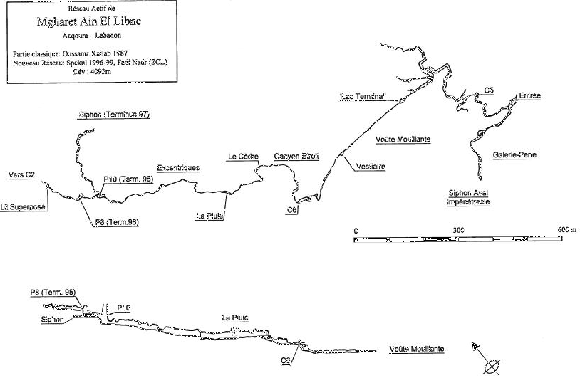
Mgharet Ain el Libne (Aaqoura)
The downstream end of Mgharet Ain el Libne, on the Aaqoura plateau,
was explored by Lebanese cavers in 1962, one year later the upstream
end was discovered (1300m). British cavers visited the cave and
partially climbed the cascade at the end of the cave. In 1987 the known
parts were mapped by GERSL. The Cascade Terminale, was climbed through
a series of chimneys in 1993-94 by ALES to reach a second level.
In September 1995, the area above the lake was further explored by
Spekul. Using our aluminum scaling pole, we discovered a third and
fourth floor (105m above the lake, total development: 460m).
During the same trip, another team checked the inlet which fed into the
lake; here a wet crawl of about 200m gave way to an active meander,
which seemed to go on forever. It was Fadi Baeyno (ALES) who reached
the end, a 10m high cascade in 1996. In the summer of that year, Spekul
explored higher levels (second and third floor) in the new part, and
the whole meander (1.5 km) was surveyed.
In the summer of 1997 we managed to get up the 10m cascade, after many
hours of climbing and maypoling. Behind the cascade, the right-hand
lead was explored for 400m up to a mud sump. The passage on the left,
which is more narrow remained unexplored.
One year later, the gallery towards the sump was surveyed, the other
end was explored for some 40m… to end in another bell-shaped chamber
where an 8m cascade came down.
This cascade was climbed in 1999, using the maypole as a fishing rod.
In front of us, the ever ongoing and narrowing meander, which was
followed for some 400m (175m surveyed, with the help of Fadi Nadr
(SCL)). We stopped at a 2m cascade, which will probably be climbed
later on this year. The cave is now both Lebanon’s third longest and
deepest cave, with a total surveyed length of 4093m, and a denivelation
of 212m.
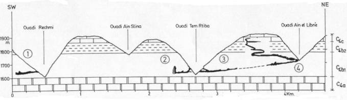
Figure 1: Simplified section through part of the Aaqoura massif.
(1) Mgharet Rechmi, (2) Mgharet Merheb, (3) Nabaa el Kiddab, (4) Ain el
Libne. C4a: Lower Cenomanian, 200m layer. C4b: Middle Cenomanian,
totaling 260m in two parts; C4b1 (180m) and C4b2 (80m). C4c: Upper
Cenomanian, limestone and dolomitic limestone. (A.Ghaouche & O.
Kallab 1991, V. Coessens & L. Debontridder 1999)
Mgharet Merheb (Aaqoura)
Mgharet Merheb is another cave on the Aaqoura plateau. It was explored
over more than 100m by local villagers up to a 7m pitch that gave into
the active level. It was explored and mapped (302m) by GERSL in 1989.
They ended in a large chamber with a lake below a 25m cascade.
Hoping to find the same kinds of galleries as in the nearby cave of Ain
el Libne (this cave develops in the same kind of limestone) we
attempted to climb this cascade. A lot of effort and adrenaline was put
in this undertaking. It took us three days to reach the top of the
cascade and another day to get on top of the pitch above it, from which
a 50m free hang can be rigged. Unfortunately, the active part gets too
narrow very soon, where the water comes out of a small hole. An attempt
was made to find a high level bypass. This led to the discovery of a
very beautiful fossil meander with some remarkable formations, which
again ended after some 70m. The survey however shows that both levels
are superimposed; a more thorough search or even a dig might lead back
into the active level. Blasting remains an option in the active part.
Climbing the pitch in Mgharet Merheb is probably one of the most
spectacular climbs ever undertaken in Lebanon.
Mgharet Jbab (Bouhairet Toula)
 This resurgence, used as drinking water supply,
was explored for 40m by SCL in 1986 and ALES in 1993. Both teams
abandoned exploration of this narrow and lowering water passage, due to
lack of wetsuits.
This resurgence, used as drinking water supply,
was explored for 40m by SCL in 1986 and ALES in 1993. Both teams
abandoned exploration of this narrow and lowering water passage, due to
lack of wetsuits.
In November 1995 the cave was visited by Steve and Lieve (Spekul).
Behind the lowest passage, they continue to crawl on hands and knees
through a one meter wide riverbed. A 10m wide
and 6m high chamber is reached, filled with large blocks. Further on,
the right side of a beautifully decorated junction terminates after
about 35m, where the roof meets the bottom. The left side again leads
to a widening passage, where an alternation of 5cm strata (clay and
limestone) can be admired on the right. A fossil passage the leads to a
lake below a 4m cascade. At this point, there is about 400m of
limestone above us!
One week later we return to the cave, together with Fadi Baeyno (ALES).
Using far Western techniques and the support of all gods of the 16
different official Lebanese religions, we managed to climb the cascade.
The meander behind it, unfortunately gets too narrow after 15 meters.
The cave was mapped by ALES in early 1996. They measured 725m of
development. The highest point on top of the cascade lies 32m above the
entrance level.
Entrance of Mgharet Jbab
References
ALES, 1996. Speleorient 1. 96p.
COESSENS, VINCENT. 1997. Libanon 1996-1997, het vervolg van de Spekul
exploraties. Spelerpes nr 83: 10-20.
COESSENS, VINCENT. 1998. Expés Spekul 96-97 au Liban. Regards nr
31 : 2-10.
COESSENS, VINCENT. 2000. Libanon 1999, exploraties op het Aaqoura en
Tannourine Plateau. Spelerpes nr 89 : 50-55.
GERSL. 1988. Liban Souterrain nr 1. 51p.
GERSL. 1991. Liban Souterrain nr 3. 82p.
GERSL 1998. Liban Souterrain nr 5. 380p.
SCL 1999. Al Ouat’Ouate nr 11. 138p.
SMEYERS, STEVE. 1996. Grotten in Libanon, verslag van de Spekul
exploraties. Spelerpes nr 79: 3-11.